


Longest day of the expedition by far. I think I did everything that could be done today. I got rained on, went over a Continental Divide 3x, went nearly 150 miles, and saw a whole lotta animals. I could technically split the day in two days, before and after Yellowstone. I awoke at 6am and was out on the road by 6:45 in the hopes of beating the winds the weather channel was forecasting for the day. Ennis seemed to be a big fly fisherman’s paradise, a sort of hardy subculture I was never aware of…
As soon as I got out of town I was hit head on with 15 – 20 mph winds that kept me at a steady 10 mph pace for about 40 miles up the valley of Montana. As a reference I was going 10 mph up the mountain pass the day before (with the help of the menacing storm). Along the way I saw some curious small land developments of a handful of expensive looking houses which in Montana seems kind of silly when all around are miles and miles of open land, why live right next to someone? The winds also kept the antelope close to the ground. I spotted some every now and again and tried to take pictures, they would not allow it, they are very fast animals.
The winds broke once I went into the valley of Earthquake Lake where the mosquitoes were waiting for me, and they were huge. I had stopped to take a picture of an historical marker and was immediately swarmed by the monsters. I left without the picture. They pelted me like rain drops through the valley and seemed to die on contact so I kept my pace higher than I would have liked. Resting wasn’t an option for about 30 miles. I took my helmet off for 20 miles around Hebgen Lake to keep the mosquitoes clear of my head, I didn’t want them nibbling at my brain. For folks (like me) who don’t know about Earthquake Lake, the gentleman at the visitor center way back near Hamilton told me that in the 50’s an earthquake ripped the side of a mountain off and basically buried alive many folks in a campground below. There was a visitor center at the quake site but I did not stop for fear of getting sucked dry of my blood. When I came over the dam I didn’t see what the big deal was until I was about a mile down the road and looked back – there was half a mountain staring back. Time has stood still in the valley, nothing grows on the face of the mountain. The lake that was formed when it dammed the river killed the remaining trees in the valley and they stand as lifeless white spires today.
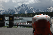
I made it to West Yellowstone (71 miles from Ennis) in record slow time of about 6 hours, had lunch at a small café, and then visited a bike shop. Both establishments already seemed to suffer from tourist fatigue early in the season, I’m sure they get the same questions day in and day out. They went through the motions and that was about it. I didn’t spend much time there though I should have when looking back now 150 miles into the day… I headed into Yellowstone around 3pm thinking I would catch the campsites 30 miles in on the south side. The folks at the bike shop told me about the numerous campgrounds on the south side. I decided I would head at least the 30 miles into the park despite the two looming passes I had to cross to get to the site. The closest campground was 14 miles in and I thought it too close for a following rest day.
Within a few miles of entering the park I was met face to face with the enormous bison. Remembering as a kid the ranger’s horror stories of kids getting mauled after getting too close to the bison I made sure to put a truck between me and the giants. Their horns were the size of my head, and I’m sure I looked inviting.
The next turnoff was littered with more bison and some photographers were walking around them, so this time I was a little braver and rolled through the turnoff and rode next to the bison. They were just slowly making their way in one direction and would raise their heads just slightly to recognize my existence. I still consider my fear a healthy one. I’ll let the photogs do their job and I’ll just get a postcard.
After passing the Madison campground it was 16 miles to Old Faithful, something I hadn’t seen in almost 20 years. 20 years ago when I visited as a kid in the early 90s there wasn’t much there except the lodge originally built a while ago (don’t quiz me, Wiki will know the exact date, I’m saying early 1900s). Now it’s an expanse of a compound with cafeteria, clinic, additional lodging, cabins, employee recreation, more gift shops, and so on. I think there were 3 separate parking lots. The entrance to the geyser even had an overpass off the main road for easier vehicle access. The ranger would make an announcement over PA when the next eruption would be. When I went years ago there was just a clock hanging on a tree. As luck would have it, I arrived just in time for the geyser’s show. There were some ominous clouds in the background so it made for bad pictures. I later found that the clouds weren’t rain clouds but winter snow clouds… I bought some small stuff after another lunch and asked about the camping in the miles ahead. The ranger said they were all closed due to snow cover. The southern boy in me was incredulous that the sites were completely snow covered. There wasn’t any snow around Old Faithful! I checked the mileage, I would have another 45 miles and 3 passes to go over, and it was 7pm. Based on history it would put me into Teton around 10pm and at least 12 hours on the bike. I went over to the lodge and asked about what they had available - $500 for a suite. I think the kid behind the counter was also suffering from tourist fatigue and probably was wondering why this guy in tights didn’t make reservations earlier like everyone else (who was a boy scout).
I decided to head to Teton 45 miles away. As I reflect now, if you bike into Yellowstone, make sure it’s later in the summer when all the campgrounds are open. And no, I was not a boy scout in the early ages so preparing for something takes the fun out of the surprise, good or bad. Biking Yellowstone should be a separate trip, one could spend at least a week exploring the area.
As I crested the second pass and continental divide, the view of the mountains were starkly different than in Montana. Montana’s mountains had that romantic picturesque snow topped peaks above the tree line. In the southern part of Yellowstone, it was as if I stepped right into a very cold winter I had never seen as a southern boy from North Carolina. There was more snow on the ground than bare ground. Snow, in this case ranged between 1 and 5 feet with the immediate trees next to the road swallowed by the snow pushed to the side by plows. The snow clouds above which blocked out the sun I was accustomed to also set the mood. I’m not a winter fan so please understand I equate winter with death and seeing a 360 degree view of death was a little unnerving. All I had going for me was a little strip of asphalt that was wet which could potentially turn to ice like its brethren snow piled up all around me. My lifeline was going to freeze and I had to get off the mountain!
The 3 passes I needed to go over were a cinch, I’m not sure what the elevation gain was but it didn’t feel like much. At the time I didn’t know they were each continental divides so I was a little aggravated that I kept crossing it. Divides are inherently divisive, they indicate a difference between one side from another and would seem linear. They should not meander around like some kind of bumbling river. If I cross a divide, I should not have to cross it again until I get to North Carolina. It’s kind of like when I briefly went back into Idaho from Montana to get to Jackson, Montana, I was done with Idaho and did not want to move backwards. Only forward!
By the third pass the sun was starting to go down, I don’t think it was much of a pass at all. It was some sign stuck aimlessly along the road with little elevation change. Passes, like divides, should be divisive as well. This is the whole reason why people want to go over them. Southern Yellowstone reminded me more of the rolling hills in the Carolinas, which was fine with me as I rolled through them in the twilight hours.
I was also quickly reminded that animals feed at sundown. I saw the bison earlier, but then came the elk… and lots of meeses (moose for the grammatically unchallenged)! At long last, I saw the enigmatic moose. Now see, if I planned out everything like a boy scout, I wouldn’t have seen my moose because I would have already found a place to stay like a good boy by the evening’s animal show. Later on I saw a coyote walking along the road too, which made me wonder if I was going to be a target for wolves like the bartender from Jackson had warned. I told the coyote it could not eat me and it lowered its neck as if it were admitting the guilt of thinking it.
The southern part of Yellowstone is basically stuck in winter, and it’s a couple days from June. I was very surprised by the difference between the lazy creeks slurping through green grass and lumbering bison in the western part of the park. By 9pm the sun set over the very frozen (yes, patchy, but very frozen) Lewis Lake and the roads were wet from runoff which worried me if it were to freeze on my descent into Teton. Imagine the tension in my mind wondering if wolves were after me going 30 mph in the dark down broken pavement. My demons haunt me in so many forms. Cold and very wet, I was glad to arrive at my destination by 10pm. It was definitely a long day, and too dark to pitch a tent so I coughed up the dough for another cabin. But the day was rewarding, I wish I could have gotten better pictures of the sunset over Lewis Lake and the snow covered canyons, but you’ll just have to see them for yourself… or Flickr.
Calories today were a healthy bleu cheese burger with some kind of cheesy potato soup, a clif bar, a ham and cheese Panini, 20 oz of root beer, 20 oz of coke, 2 servings of Endurox, and a whole lotta water.
I can’t decide what I’m going to do tomorrow, maybe head further south about 30 miles to the next and more favorable campground in Teton or stay here in the northern part of the park. I imagine I’ll head south since I have to pack everything to leave this cabin anyways at a completely sensible $189 a night without a TV and internet. Last night had direct TV, fridge, and wifi for $54… Better than a $500 suite I suppose.
Yellowstone is in a transition and is at conflict with its own space and how people define it. I bought a bottle of wine at the Old Faithful grocery store. I suppose I could have capped it off with a night in a “suite”. People who come here want rugged yet the roads in Yellowstone seem to be the heaviest traveled I’ve experienced so far, especially by RV. People I observed won’t get so far as 30 feet from their car for a photo opportunity of a bird’s nest or bison. Then off to the next sight, and dammit there’s that biker again we just passed, let's buzz'em. Add to the image of trucks with campers attached to its bed. I felt like it was a redneck safari not far off from Disney’s animal kingdom concept… I bet there are plans for a wild sushi restaurant and massage for those laborious hours in the car. Either way, it’s indispensible education if people would stop and read the notes on the roadside about the history of the park. I think for most it’s just part of the bucket list.
BODY CHECK
After a week into the ride I thought I’d share some observances about my body. When I applied for life insurance they gave me a physical, I weighed 170 lbs which is heavy for me in May. I look as though I’ve lost around 10 lbs given the fat on the inside legs, lower abdomen, and around the creases of the arms have thinned. I look like a Klingon with my 3 striped helmet tan forehead. The tan lines on the arms and legs are incredible. My knees are benefitting from my experiment in OTC anti-inflammatory medication, I’ve settled on Aleve, which I credit for my day’s ride and ability to put in 150 miles. Everything else is fine. The undercarriage has healed and hardened from 950 miles on the bike. I fully expected to have trap pain, lower back pain, tricep pain, etc. All of these pains are eliminated because when I’m riding 30 miles in a straight line on a clean road, I just put my head down and go. In NC, there are too many potholes, broken pavement, rocks, parked cars (inside joke), and other obstacles to prevent a time trial style ride. The legs were a little tired today and threatened to cramp in the quads, a first for the ride.
As soon as I got out of town I was hit head on with 15 – 20 mph winds that kept me at a steady 10 mph pace for about 40 miles up the valley of Montana. As a reference I was going 10 mph up the mountain pass the day before (with the help of the menacing storm). Along the way I saw some curious small land developments of a handful of expensive looking houses which in Montana seems kind of silly when all around are miles and miles of open land, why live right next to someone? The winds also kept the antelope close to the ground. I spotted some every now and again and tried to take pictures, they would not allow it, they are very fast animals.
The winds broke once I went into the valley of Earthquake Lake where the mosquitoes were waiting for me, and they were huge. I had stopped to take a picture of an historical marker and was immediately swarmed by the monsters. I left without the picture. They pelted me like rain drops through the valley and seemed to die on contact so I kept my pace higher than I would have liked. Resting wasn’t an option for about 30 miles. I took my helmet off for 20 miles around Hebgen Lake to keep the mosquitoes clear of my head, I didn’t want them nibbling at my brain. For folks (like me) who don’t know about Earthquake Lake, the gentleman at the visitor center way back near Hamilton told me that in the 50’s an earthquake ripped the side of a mountain off and basically buried alive many folks in a campground below. There was a visitor center at the quake site but I did not stop for fear of getting sucked dry of my blood. When I came over the dam I didn’t see what the big deal was until I was about a mile down the road and looked back – there was half a mountain staring back. Time has stood still in the valley, nothing grows on the face of the mountain. The lake that was formed when it dammed the river killed the remaining trees in the valley and they stand as lifeless white spires today.
I made it to West Yellowstone (71 miles from Ennis) in record slow time of about 6 hours, had lunch at a small café, and then visited a bike shop. Both establishments already seemed to suffer from tourist fatigue early in the season, I’m sure they get the same questions day in and day out. They went through the motions and that was about it. I didn’t spend much time there though I should have when looking back now 150 miles into the day… I headed into Yellowstone around 3pm thinking I would catch the campsites 30 miles in on the south side. The folks at the bike shop told me about the numerous campgrounds on the south side. I decided I would head at least the 30 miles into the park despite the two looming passes I had to cross to get to the site. The closest campground was 14 miles in and I thought it too close for a following rest day.
Within a few miles of entering the park I was met face to face with the enormous bison. Remembering as a kid the ranger’s horror stories of kids getting mauled after getting too close to the bison I made sure to put a truck between me and the giants. Their horns were the size of my head, and I’m sure I looked inviting.
The next turnoff was littered with more bison and some photographers were walking around them, so this time I was a little braver and rolled through the turnoff and rode next to the bison. They were just slowly making their way in one direction and would raise their heads just slightly to recognize my existence. I still consider my fear a healthy one. I’ll let the photogs do their job and I’ll just get a postcard.
After passing the Madison campground it was 16 miles to Old Faithful, something I hadn’t seen in almost 20 years. 20 years ago when I visited as a kid in the early 90s there wasn’t much there except the lodge originally built a while ago (don’t quiz me, Wiki will know the exact date, I’m saying early 1900s). Now it’s an expanse of a compound with cafeteria, clinic, additional lodging, cabins, employee recreation, more gift shops, and so on. I think there were 3 separate parking lots. The entrance to the geyser even had an overpass off the main road for easier vehicle access. The ranger would make an announcement over PA when the next eruption would be. When I went years ago there was just a clock hanging on a tree. As luck would have it, I arrived just in time for the geyser’s show. There were some ominous clouds in the background so it made for bad pictures. I later found that the clouds weren’t rain clouds but winter snow clouds… I bought some small stuff after another lunch and asked about the camping in the miles ahead. The ranger said they were all closed due to snow cover. The southern boy in me was incredulous that the sites were completely snow covered. There wasn’t any snow around Old Faithful! I checked the mileage, I would have another 45 miles and 3 passes to go over, and it was 7pm. Based on history it would put me into Teton around 10pm and at least 12 hours on the bike. I went over to the lodge and asked about what they had available - $500 for a suite. I think the kid behind the counter was also suffering from tourist fatigue and probably was wondering why this guy in tights didn’t make reservations earlier like everyone else (who was a boy scout).
I decided to head to Teton 45 miles away. As I reflect now, if you bike into Yellowstone, make sure it’s later in the summer when all the campgrounds are open. And no, I was not a boy scout in the early ages so preparing for something takes the fun out of the surprise, good or bad. Biking Yellowstone should be a separate trip, one could spend at least a week exploring the area.
As I crested the second pass and continental divide, the view of the mountains were starkly different than in Montana. Montana’s mountains had that romantic picturesque snow topped peaks above the tree line. In the southern part of Yellowstone, it was as if I stepped right into a very cold winter I had never seen as a southern boy from North Carolina. There was more snow on the ground than bare ground. Snow, in this case ranged between 1 and 5 feet with the immediate trees next to the road swallowed by the snow pushed to the side by plows. The snow clouds above which blocked out the sun I was accustomed to also set the mood. I’m not a winter fan so please understand I equate winter with death and seeing a 360 degree view of death was a little unnerving. All I had going for me was a little strip of asphalt that was wet which could potentially turn to ice like its brethren snow piled up all around me. My lifeline was going to freeze and I had to get off the mountain!
The 3 passes I needed to go over were a cinch, I’m not sure what the elevation gain was but it didn’t feel like much. At the time I didn’t know they were each continental divides so I was a little aggravated that I kept crossing it. Divides are inherently divisive, they indicate a difference between one side from another and would seem linear. They should not meander around like some kind of bumbling river. If I cross a divide, I should not have to cross it again until I get to North Carolina. It’s kind of like when I briefly went back into Idaho from Montana to get to Jackson, Montana, I was done with Idaho and did not want to move backwards. Only forward!
By the third pass the sun was starting to go down, I don’t think it was much of a pass at all. It was some sign stuck aimlessly along the road with little elevation change. Passes, like divides, should be divisive as well. This is the whole reason why people want to go over them. Southern Yellowstone reminded me more of the rolling hills in the Carolinas, which was fine with me as I rolled through them in the twilight hours.
I was also quickly reminded that animals feed at sundown. I saw the bison earlier, but then came the elk… and lots of meeses (moose for the grammatically unchallenged)! At long last, I saw the enigmatic moose. Now see, if I planned out everything like a boy scout, I wouldn’t have seen my moose because I would have already found a place to stay like a good boy by the evening’s animal show. Later on I saw a coyote walking along the road too, which made me wonder if I was going to be a target for wolves like the bartender from Jackson had warned. I told the coyote it could not eat me and it lowered its neck as if it were admitting the guilt of thinking it.
The southern part of Yellowstone is basically stuck in winter, and it’s a couple days from June. I was very surprised by the difference between the lazy creeks slurping through green grass and lumbering bison in the western part of the park. By 9pm the sun set over the very frozen (yes, patchy, but very frozen) Lewis Lake and the roads were wet from runoff which worried me if it were to freeze on my descent into Teton. Imagine the tension in my mind wondering if wolves were after me going 30 mph in the dark down broken pavement. My demons haunt me in so many forms. Cold and very wet, I was glad to arrive at my destination by 10pm. It was definitely a long day, and too dark to pitch a tent so I coughed up the dough for another cabin. But the day was rewarding, I wish I could have gotten better pictures of the sunset over Lewis Lake and the snow covered canyons, but you’ll just have to see them for yourself… or Flickr.
Calories today were a healthy bleu cheese burger with some kind of cheesy potato soup, a clif bar, a ham and cheese Panini, 20 oz of root beer, 20 oz of coke, 2 servings of Endurox, and a whole lotta water.
I can’t decide what I’m going to do tomorrow, maybe head further south about 30 miles to the next and more favorable campground in Teton or stay here in the northern part of the park. I imagine I’ll head south since I have to pack everything to leave this cabin anyways at a completely sensible $189 a night without a TV and internet. Last night had direct TV, fridge, and wifi for $54… Better than a $500 suite I suppose.
Yellowstone is in a transition and is at conflict with its own space and how people define it. I bought a bottle of wine at the Old Faithful grocery store. I suppose I could have capped it off with a night in a “suite”. People who come here want rugged yet the roads in Yellowstone seem to be the heaviest traveled I’ve experienced so far, especially by RV. People I observed won’t get so far as 30 feet from their car for a photo opportunity of a bird’s nest or bison. Then off to the next sight, and dammit there’s that biker again we just passed, let's buzz'em. Add to the image of trucks with campers attached to its bed. I felt like it was a redneck safari not far off from Disney’s animal kingdom concept… I bet there are plans for a wild sushi restaurant and massage for those laborious hours in the car. Either way, it’s indispensible education if people would stop and read the notes on the roadside about the history of the park. I think for most it’s just part of the bucket list.
BODY CHECK
After a week into the ride I thought I’d share some observances about my body. When I applied for life insurance they gave me a physical, I weighed 170 lbs which is heavy for me in May. I look as though I’ve lost around 10 lbs given the fat on the inside legs, lower abdomen, and around the creases of the arms have thinned. I look like a Klingon with my 3 striped helmet tan forehead. The tan lines on the arms and legs are incredible. My knees are benefitting from my experiment in OTC anti-inflammatory medication, I’ve settled on Aleve, which I credit for my day’s ride and ability to put in 150 miles. Everything else is fine. The undercarriage has healed and hardened from 950 miles on the bike. I fully expected to have trap pain, lower back pain, tricep pain, etc. All of these pains are eliminated because when I’m riding 30 miles in a straight line on a clean road, I just put my head down and go. In NC, there are too many potholes, broken pavement, rocks, parked cars (inside joke), and other obstacles to prevent a time trial style ride. The legs were a little tired today and threatened to cramp in the quads, a first for the ride.
Keep it up James!! Youll pass over the continental divide again in CO when you do Ride The ROckies. just keep those Craft shifts and underwear I gave you close at hand at there. youre right, it can go from spring to winter there in a heartbeat. Just keep your winter gear in check. and the roads probably wont ice over, as the ground is thawed out.
ReplyDeletekeep it up, take pics at night when you can charge your phone!
great post! Keep it up buddy. Can't wait to see the pics.
ReplyDeletePosting pics as FB and the internet gods will allow :)
ReplyDelete